THE TOYNTON VILLAGES BEFORE AND AFTER ENCLOSURE
It is evident that the inhabitants of the two villages lived a kind of double life. The East Fen certainly provided one type of livelihood. But it was the fields and common land close to the village centres that allowed the commoners to graze livestock in the winter, and to grow crops on strips that were ploughed for their use. It is clear from both the following surveys that before enclosure in 1774, the majority of the land was common land described as Open Fields.
This combination of farming on common land close to the villages and the benefits they gained from the open East Fen meant that the commoners living in the Toyntons must have enjoyed a reasonable and independent lifestyle for many centuries. This was all to change with the draining and enclosure of East Fen and the enclosure of all the Open Fields around the villages.
The enclosure of the two Toynton Villages is described in two parts. The first is the situation at the beginning of the seventeenth century as detailed in a survey carried out in 1614. This shows that some enclosure had already taken place. The second is the position at 1773 before the Enclosure Act of 1774, and then how the Act enclosed the remaining open fields.
What is interesting is that a comparison between the 1614 survey and that at 1773 showed very little had changed over that time. The question is, were the Ascoughs reliant upon the common land (Open Fields) for their livelihood or were they employed to work for the owners and tenants of the enclosed fields? My guess is probably both.
Before looking at enclosure in detail, I thought it useful to include extracts from A Short History of Enclosure in Britain that appeared in a magazine called “The Land” and is Issue 7 Summer 2009.
The Open Field System
Private ownership of land, and in particular absolute private ownership, is a modern idea, only a few hundred years old. "The idea that one man could possess all rights to one stretch of land to the exclusion of everybody else" was outside the comprehension of most tribespeople, or indeed of medieval peasants. The king, or the Lord of the Manor, might have owned an estate in one sense of the word, but the peasant enjoyed all sorts of so-called "usufructory" rights which enabled him, or her, to graze stock, cut wood or peat, draw water or grow crops, on various plots of land at specified times of year.
The open field system of farming, which dominated the flatter more arable central counties of England throughout the later medieval and into the modern period, is a classic common property system which can be seen in many parts of the world. The structure of the open fields system in Britain was influenced by the introduction of the caruca a large wheeled plough, developed by the Gauls, which was much more capable of dealing with heavy English clay soils than the lightweight Roman aratrum (Fr araire). The caruca required a larger team of oxen to pull it —as many as eight on heavy soils — and was awkward to turn around, so very long strips were ideal. Most peasants could not afford a whole team of oxen, just one or two, so maintaining an ox team had to be a joint enterprise. Peasants would work strips of land, possibly proportionate to their investment in the ox team. The lands were farmed in either a two or three course rotation, with one year being fallow, so each peasant needed an equal number of strips in each section to maintain a constant crop year on year.
Furthermore, because the fields were grazed by the village herds when fallow, or after harvest, there was no possibility for the individual to change his style of farming: he had to do what the others were doing, when they did it, otherwise his crops would get grazed by everyone's animals. The livestock were also fed on hay from communal meadows (the distribution of hay was sometimes decided by an annual lottery for different portions of the field) and on communal pastures.
A quotation from C S Orwin’s “Open Fields” follows: "A man may have no more than an acre or two, but he gets the full extent of them laid out in long "lands" for ploughing, with no hedgerows to reduce the effective area, and to occupy him in unprofitable labour. No sort of inclosure of the same size can be conceived which would give him equivalent facilities. Moreover he has his common rights which entitle him to graze his stock all over the 'lands' and these have a value, the equivalent of which in pasture fields would cost far more than he could afford to pay."
In short, the common field system, rather ingeniously, made economies of scale, including use of a whopping great plough team, potentially accessible to small scale farmers. The downside was a sacrifice of freedom (or "choice" as it is now styled), but that is in the nature of economies of scale when they are equitably distributed — and when they are inequitably distributed some people have no choice at all.
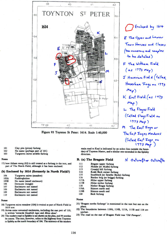
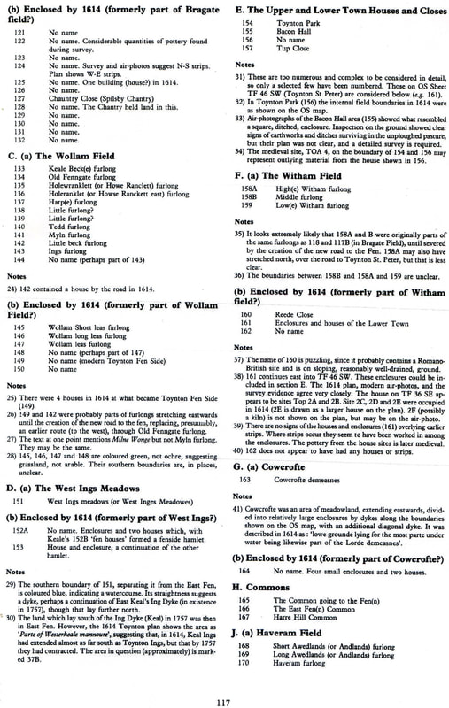
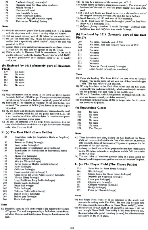
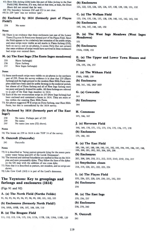
THE 1614 SURVEY OF THE MANOR OF TOYNTON
Enclosure of some of the fields around the two villages had already taken place before the beginning of the seventeenth century. However, there were still large open fields as shown in the following survey.
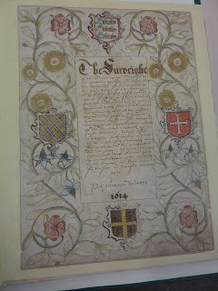
On the 20th November 1614, in the reign of King James 1, there took place The Surveighe of the Mannour of Toynton. This survey identified by way of maps, the strips of land (furlongs) and the relevant freeholders (landowners), and tenants. It also identified which were open fields and which were enclosed. The original document is available in Lincolnshire Archives (thanks again to their website lincstothepast) and, on my visit there, I was able to take photographs from this magnificent document.
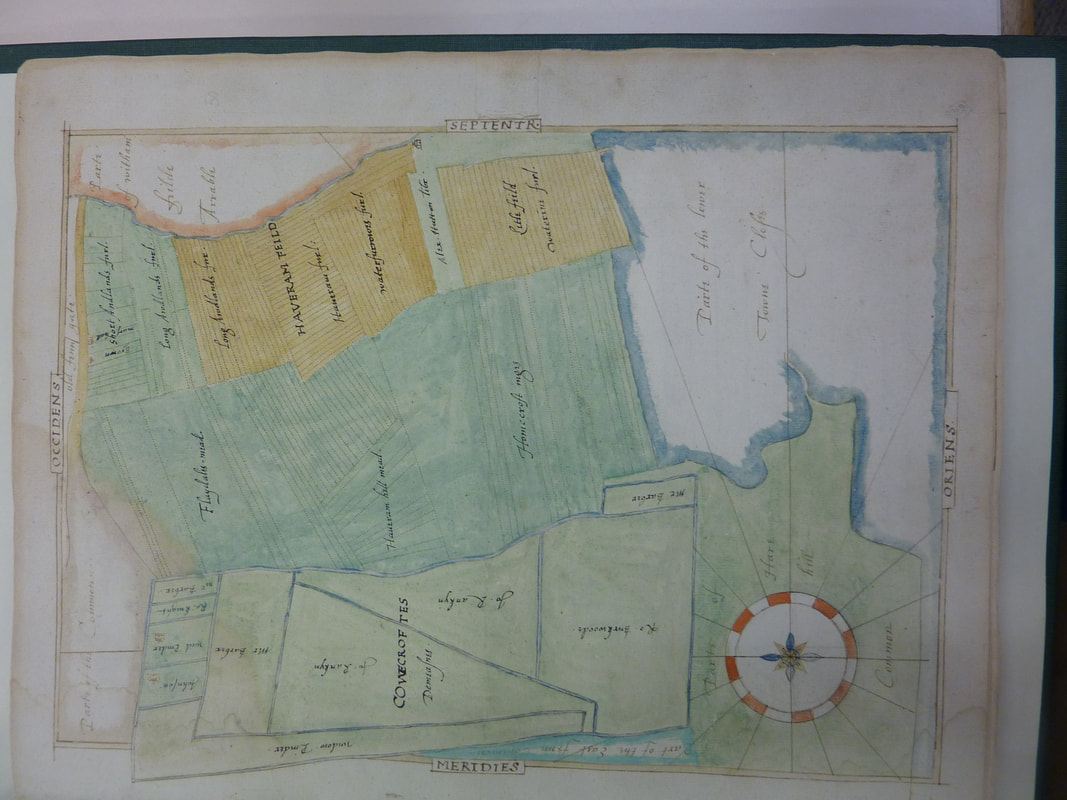
The following Pages are taken from Fenland Project No 8: Lincolnshire Survey, The Northern Fen Edge. This publication has studied in detail the Survey and has divided the fields into open fields and those that have already been enclosed by 1614.
The following extracts are reproduced with kind permission of Heritage Trust of Lincolnshire.
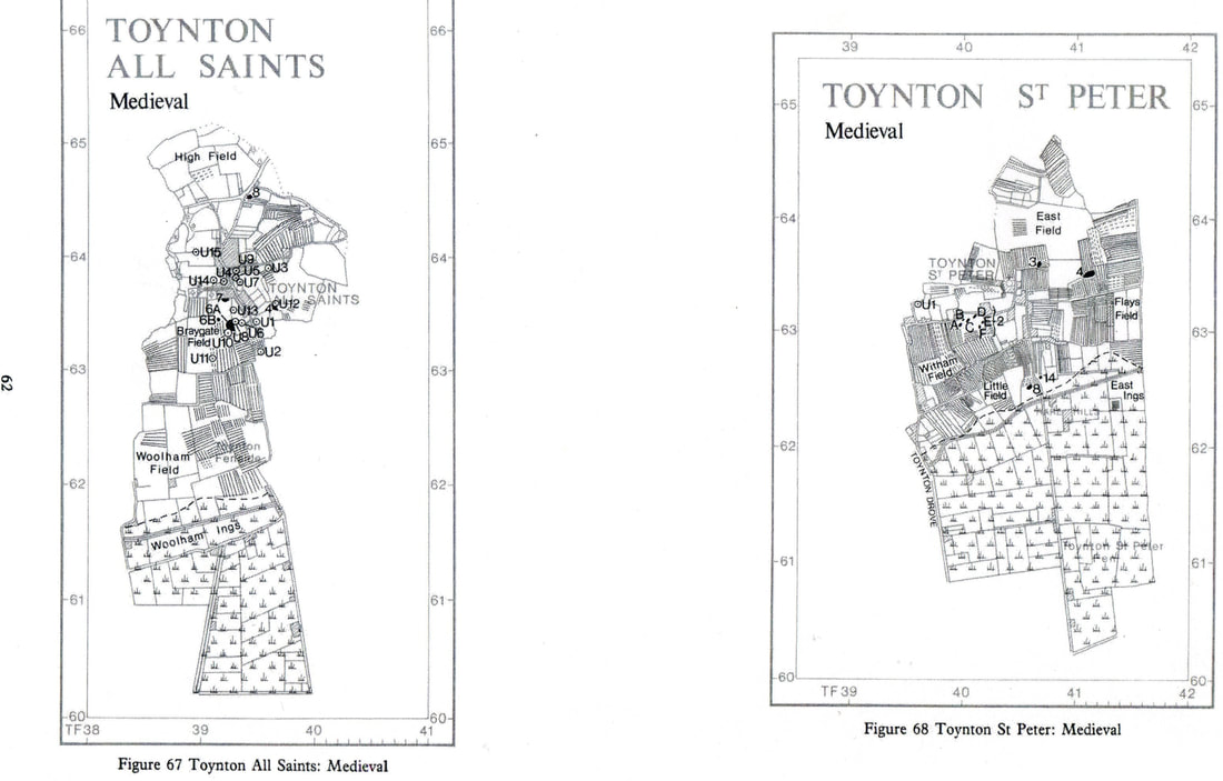
The position of individual strips and furlongs within the early post-medieval field systems of … Toynton All Saints and Toynton St Peter are available from these documents (i.e. the 1614 Survey). These are shown in the following maps in Appendix IX (Figs 92 - 93).
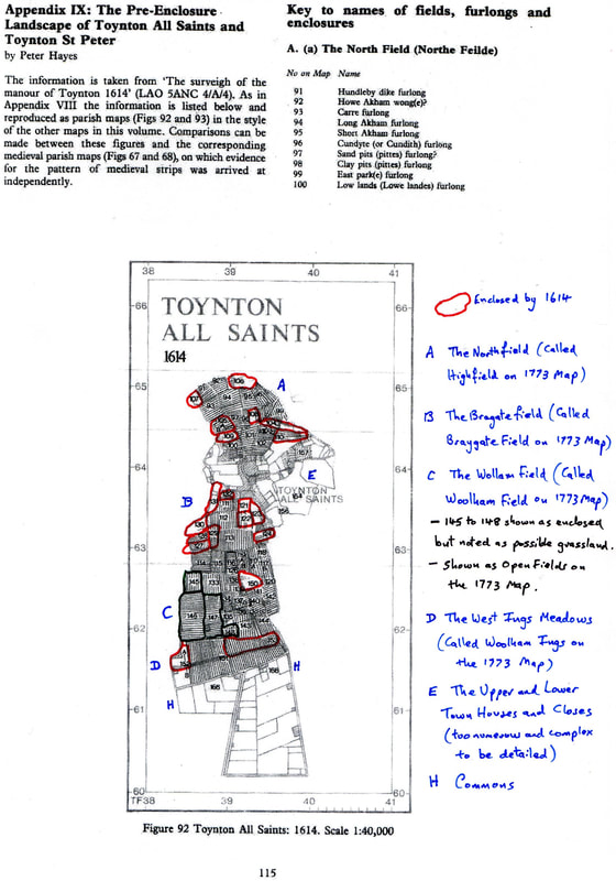
The maps above can be compared with the medieval parish maps that follow.
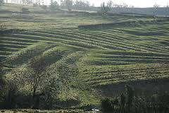
Below is a picture of a typical open field cultivated in strips, each being of one acre.

THE ENCLOSURE OF TOYNTON ALL SAINTS AND TOYNTON ST. PETER’S: 1773 - 1774
David Grigg, in his The Agricultural Revolution in South Lincolnshire, tells us that: In 1750, in spite of several centuries of enclosing, about half the cultivated area of England was still farmed in the Open Field system. Farms consisted of a number of strips, scattered among the open fields, which were unfenced and subject not only to common rotation, but to common grazing after each harvest.
This is undoubtedly true for the Toynton parishes as can be seen in the maps above. These open fields are, in essence, the same as those described in 1773 in the publication Old and New Landscapes in the Horncastle Area by Eleanor and Rex C. Russell as the following extracts:
FOREWORD
The documents on which this book is based – Enclosure Acts and Awards, Commissioners notices and minutes, copies of eighteenth and nineteenth century newspapers, Lincolnshire Archives etc.
INTRODUCTION
In the area examined, during the seventy years after 1757, hundreds of miles of new hawthorn hedges were planted in straight lines to divide and enclose previously open, un-hedged fields and commons. Scores of miles of new roads were staked out over the meadows, moors, commons and arable fields. In the low lying parishes many miles of new drains were dug to improve field drainage. Some roads followed entirely new courses; others followed the courses of existing old roads.
(Comparing the Toynton St Peter and All Saints maps, both is true for this area)
In many parishes, few people were awarded land.
It is my guess that these new fields needed a workforce and the Ascough’s (who were not awarded land) were probably involved.
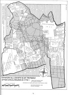
These new landscapes for each parish were normally planned separately. They were designed by Enclosure Commissioners and their skilled Surveyors. Planned first on paper, designed on drawing boards by Surveyors using rulers and straight edges, the resulting grid patterns were then staked out over the fields and commons. They are clearly visible today. We can still see the contrast between the smaller closes which form the centre of villages, closes in which hedges tend to be curved and irregular and composed of several hedgerow species; and the larger rectangular fields created by enclosure.
These newer hedges tend to be predominantly hawthorn. Today we can still observe the great differences between the older winding lanes – usually below the level of the adjoining field, worn down by centuries of use – and the newer, straight roads with their wide grass verges designed and laid out at enclosure. On the maps that follow all the old enclosures (the hedges closes which already existed as enclosures before the remainder of the parish was divided and enclosed) are always shown shaded. Notice their irregular shapes, see how the narrow winding lanes within them contrast with the wider and straighter new enclosure roads.
As it was normal for an Enclosure Act to authorise division and allotment within a single parish, our present-day landscape was designed parish by parish. Study a six-inch Ordnance Survey map and this point becomes very clear – very few hedges cross parish boundaries, many roads change their alignments and their widths at parish boundaries.
Enclosures, of course, changed much more than the face of the land. It replaced the two, three, four or more open fields round a village, in which strips were owned individually, but where cropping and stocking were managed and controlled by the community of farmers, by smaller hedges and fenced (i.e. enclosed) fields in the ownership of one person. Within these newly created fields the cropping and stocking were no longer the concern of the community. The individual owner and his tenant farmer had full control within each field. Enclosure helped??? to change rural society as markedly as it changed the landscape.
DISCUSSION OF INTENDED ENCLOSURES
Before a Bill for the enclosure of a parish was drafted, discussions took place amongst the owners of the land, tithes and common rights to consider the expediency of enclosure and to work out the main provisions to be included in the Bill. Who should be chosen as Commissioners and Surveyors. Meetings were advertised in the local paper.
There were occasions where two (or three) adjoining parishes were enclosed with one Act including Toynton All Saints and Toynton St Peter.
John Ascough (1758 – 1844) would have been sixteen and his father Thomas (born 1735) was 39 in 1774 when Enclosure took place.
THE ENCLOSURE OF TOYNTON ALL SAINTS AND TOYNTON ST PETER’S: 1773-1774
By 1773, a good deal of the parish was already divided into hedged closes; however 1140 acres of open arable land, ings and common were still unenclosed. Seven Open Fields still existed. They are basically the same shape, and called the same names as the 1614 survey. (See map below)
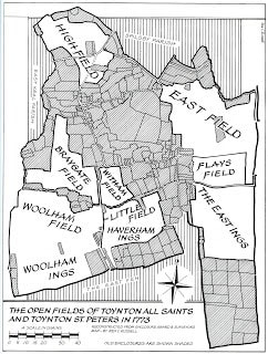
The purpose of enclosure was to divide these 1140 open acres between the individuals owning lands and enjoying Common Rights to hedge and fence the lands divided. The lands were distributed as the following map.
There is no sign of any Ascough being allotted land, so may not have enjoyed any rights of common at that time. That might have meant that they had no livestock to graze on the East fen as these would have had to be moved to the higher Open Fields in winter.
What the Enclosure does show is that the parish did not suffer from flooding as the land is slightly above the level of the East Fen. Indeed, Toynton St Peter is around 10 metres above the Fen and Toynton All Saints at 30 metres according to the latest OS map.
The southern boundary of the parish enclosure seems to be where the East Fen Catchwater Drain was placed through the Act of Parliament of 1801 and 1803.
The cost of the enclosure of Toynton All Saints and Toynton St Peter’s is stated as £1456 2.s and 10d. When the award was signed (September 1774) some of the owners had still not paid their share of the costs.
The open fields shown on the map prior to 1773 shows ings in the south of the parish such as Woolham Ings and East Ings. These are marsh lands.
The effects of enclosure is dealt with in later sections.
